MISSION — In an effort to improve drought preparedness, the Confederated Tribes of the Umatilla Indian Reservation (CTUIR) launched a new web-based dashboard that delivers early warning data to the reservation community and tribal programs.
The tribes launched the Drought Early Warning System (DEWS) dashboard in January to provide timely information that supports decision-making for the community and CTUIR programs.
This project began in 2022, when the National Integrated Drought Information System (NIDIS) awarded CTUIR a $434,000 grant to support a project focused on building Tribal Drought Resilience. While experiencing drought and flood conditions can be stressful and, at times, devastating, these events are natural parts of our ecosystem. With the right information, preparation and shared awareness, their impacts can be mitigated, helping our community adapt and move through these patterns in balance.
According to a press release, since time immemorial, CTUIR people have lived in reciprocity with the First Foods. Because of this relationship, the DEWS dashboard and the broader drought resilience effort “needed to use First Foods to understand natural conditions, so we can continue to protect, restore and enhance their livelihoods,” the release stated. “In doing so, we also protect, restore, and enhance our own.”
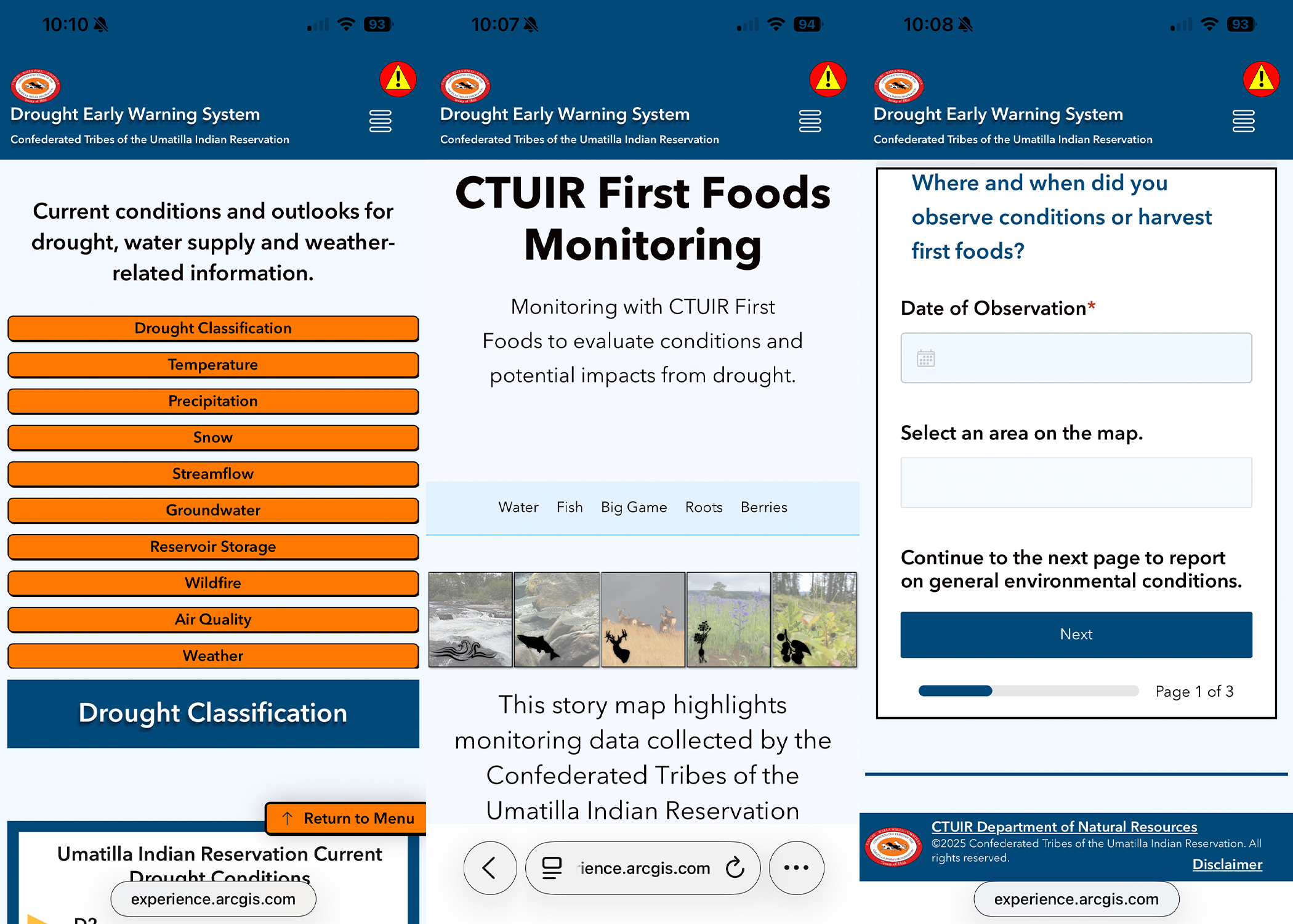
The DEWS dashboard includes a dedicated First Foods monitoring section that highlights CTUIR’s Department of Natural Resources’ (DNR) monitoring efforts for water, fish, big game, roots and berries. Throughout this section, users can learn about the effects of drought, the monitoring conducted by DNR and data provided by state and federal partners such as the U.S. Geological Survey, Oregon Water Resources Department, Columbia River Inter-Tribal Fish Commission, Bureau of Reclamation, Environmental Protection Agency, National Oceanic and Atmospheric Administration and others.
“A great example of what this site offers is found within the Čúuš (Water) section, where users will find information on streamflow, groundwater and spring monitoring, as well as surface water quality and chemistry and monitoring conducted at Lake Híyuumptípin,” the release stated. “Together, these data help paint a clearer picture of how drought conditions affect water resources across the Reservation.”
A special feature of the DEWS dashboard is its invitation for community participation. Hunters, fishers and gatherers are encouraged to contribute observations through a survey in the “Share Information” section.
Community members can submit details about the activities they are engaged in and the real-time conditions they observe on the land and water. Individual submissions will not be shared publicly and personal or sensitive locations will remain protected. At the end of each year, responses will be summarized to help track ecosystem changes relevant to climate assessments.
“This collaboration creates an opportunity to work directly with our community as they exercise Treaty Rights and continue caring for the land, water and First Foods through cultural practices,” the release stated.
The DEWS dashboard also includes a robust Current Conditions, Outlooks and Forecasts section, offering visual information on drought status, water supply and weather conditions. Additional sections — About Drought and Additional Resources — provide educational materials explaining different types of drought and conditions at the local, state, regional and national levels.
The DEWS dashboard can be accessed through CTUIR.org and is located at the bottom of the Important Links section. Community members are encouraged to explore the dashboard, share feedback and participate in the Share Information survey when out observing conditions.