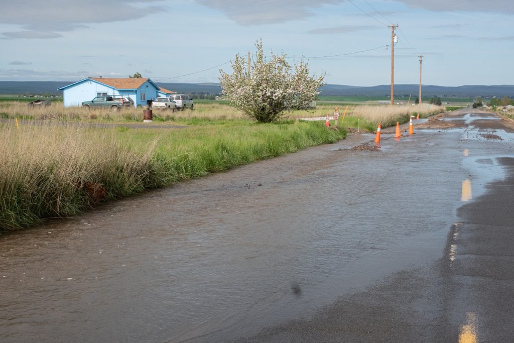
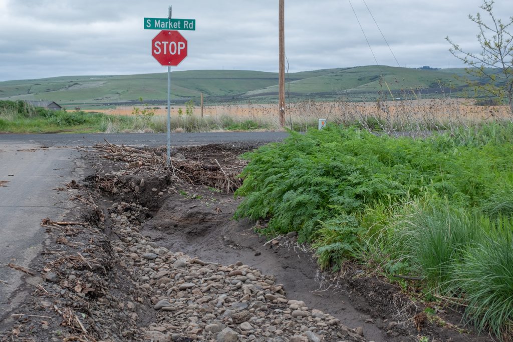
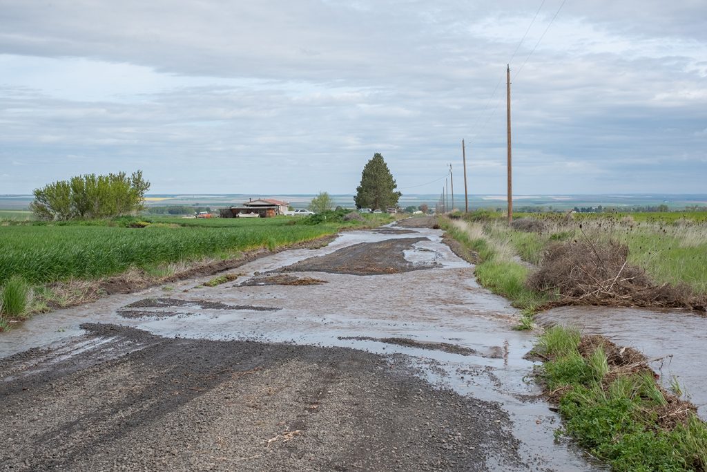
MISSION — Floodwaters overran roads on the south Umatilla Indian Reservation on April 22, including Conner, Best, Lloyd and Conner roads, along with several others near Coyote and Patawa creeks.
The surge washed out grading, damaged culverts and carved out portions of pavement, while carrying rounded river rocks and depositing them along the roadsides.
Tamástslikt Cultural Institute (Tamástslikt) Director Bobbie Conner spent the evening placing cones and hazard signs along roads near Tamástslikt after flash flooding damaged multiple roads.
Conner first noticed the flooding about 5:45 p.m. as she drove home after passing a relative’s house. She said that water was building up along the road and in the ditch and the driveway looked like it was going to wash away. The home’s electrical box was starting to lie in the ditch where water was flowing, she added.
“I called dispatch, but didn’t have direct access to anyone who could get the road closure signs, so we came and picked up Tamástslikt equipment just to get people to slow down,” she said. “After, we put them up on Conner, where the flooding was right at the T-intersection, and got small barricades up on both sides of the water running across the road on Montanic.”
Conner, along with Confederated Tribes of the Umatilla Indian Reservation (CTUIR) Environmental Health and Safety Specialist Brian Fullen, called it an evening around 8:45 p.m.
“I was enormously grateful that there were staff out after-hours helping,” she said. “It’s a big deal, especially someone who has responsibility and can put safety stuff out.”
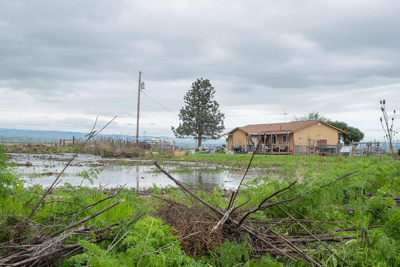
Excessive runoff flowing downhill through Patawa and Coyote creeks overwhelmed roadside ditches and culverts, cutting across roads and through properties. Floodwaters spread into the Shenandoah community, one of the more densely populated areas outside the housing projects, with about 30 to 40 homes, according to Conner.
CTUIR Water Resources Specialist Devan Noblit said challenges stem from sediment runoff throughout the reservation, which flows with overflow and clogs culverts.
“Folks were out trying to clear those culverts to help guide that water through those areas so the water levels would go down, but there is some pretty extensive damage,” Noblit said. “Not at the level seen in 2020 during that flood, but it still is pretty significant in some of these areas, especially where South Coyote Creek runs through.”
Noblit said a flooding event to this extent wasn’t a common occurrence, though some areas are more prone to smaller floods.
“The last time was 2020, and that was a hundred-year event that we saw then,” he said.”There have been smaller floods like this throughout the years, but it’s not an annual event to any extent. There are certain areas that are more prone to flood annually, but the extent of the damage we saw isn’t common to be seen.”
Whose roads are these?
Roads on the south reservation are owned by either Umatilla County or the Bureau of Indian Affairs (BIA).
Noblit said part of the problem comes down to determining which roads are owned by which entity.
“Our roads department is pretty good about maintaining, say, when it’s their culvert that gets blocked up, it gets reported and they’re pretty good about going out and cleaning those out,” she said. “It’s a little bit more challenging with the county, to have them come out and really clean those out or maintain those culverts, because there are quite a few on the reservation that are crushed. So, it takes a lot less sediment to build up than if the culvert were fully open.”
Conner said regarding the roads after flooding does not address the underlying issues.
“It doesn’t handle the culverts that were overflowing, it doesn’t handle the ditches that were blocked by somebody putting stuff in it that shouldn’t have been there,” she said.
Conner added there can be no “them and us” in moments of emergency, because everyone is a resident of the Umatilla Indian Reservation.
“We’re all driving these roads, we all have kids who have to get on the school buses, we all have livestock, pets, crops and other things to manage, sources of income,” she said. “The tribe needs an agreement with the county about working cooperatively on these kinds of issues.”
She also expressed her frustration with the county’s priority, noting the lower population density in the flooded areas of the south reservation compared with other at-risk locations.
“It’s absolutely insane, because there wasn’t any emergency readiness for this to this degree that happened. We didn’t have snowpack, we had a drought declaration, but what we got was this water event,” she said.
Info Box: South Reservation road ownership
For Umatilla County Roads info, contact Umatilla County Public Works Roads Department at (541) 278-5424
- Best Road
- Billy Road
- Conner Road
- Goad Road
- Holmes Road
- Kash Kash Road
- Lloyd Road
- Montanic Road
- Patawa Road
- Red Hawk Road
- S. Market Road
- Tias Road
- Tutuilla Church Road
- Tutuilla Creek Road
For BIA Tribal Roads info, contact CTUIR Public Works Department at (541) 429-7507
- Angus Avenue
- Brahman Way
- Charolais Street
- Durham Plaza
- Meadow Lark Lane
- Minthorn Lane
- Pond Road
- Thompson Road
- Tokti Road
- Umbarger Road
- Weedy Lane
Aren’t we in a drought?
Gov. Tina Kotek declared drought conditions for Baker, Deschutes and Umatilla counties on March 26 under Executive Order No. 26-05, citing persistent moderate drought conditions since mid-2025. The order expires on Dec. 31.
Conditions included above-normal temperatures, well-below-normal snowpack, below-normal streamflow forecasts and generally dry soil moisture conditions.
Noblit said drought conditions are closely tied to snowpack.
”Throughout the winter, we really didn’t have much snowpack,” Noblit said. “Then we have rain events like this, and it doesn’t stay in one place like snow does. This isn’t going to, in the long run, impact drought in that capacity. But yes, most of the state is in a drought and has been in a drought throughout the winter as well.”
Water Resources Director Troy Baker said the flooding event was not directly tied to the drought declaration, due to the existing lack of snowpack in the mountains.
“In 2020, we had a rain event with snow that created that high-flow event, where this was just all rain,” he said. “We had areas that picked up 2 inches of rain in 24 hours, which is a lot of water and we’ve had multiple rain events over the last few weeks, so the ground’s already saturated. When we have 2 inches of rain falling on top of that, it’s all running out in a flash flood type of event.”

Mitigation, management and moving forward
Baker said preparing for future events starts with ensuring infrastructure can handle high water volumes.
“Ensuring that the culverts are adequate for the amount of flow that we would see,
ensuring that areas where we have some of these creeks that are being farmed right up against the channel, being pushed into a narrower stream channel, that it doesn’t have a chance for that water to go over into the floodplain, to allow it to dissipate some of that energy,” Baker said.
When channels are narrowed by farming right up against them, he noted, water flows faster and can cause more damage. The flow only begins to slow down once it can spread, he said.
“I think there are some conversations that need to be had as far as, do we start looking at buffers on some of these creeks to ensure that we have the capacity for that water to lose some of the power that it has?” he said.
Conner said events like this can be fully prevented, but damage can be reduced through cooperation with Water Resources, Range, Agriculture and Forestry and other partners.
The damage that is inflicted can be mitigated through work done with in-stream permits, whether returning streams back to their original channels, creating seasonal retention or overflow ponds or upsizing culverts, she added.
Noblit said there’s a community concern as well for people in higher positions to “hold the county’s feet to the fire”, as it’s their responsibility to maintain culverts and road infrastructure that isn’t on private property.
Noblit said Water Resources has been working with different departments to come up with a plan to reroute South Coyote Creek back to the main channel to prevent further flooding of homes.
Conner said she is sad and frustrated by the extent of the damage but encouraged after speaking with Baker and CTUIR Emergency Management Coordinator Kimberly Hughes about improving preparedness for future events. She also said she is optimistic the CTUIR Board of Trustees could utilize its government-to-government relationship with the county to improve service to reservation roads.
She noted the flood carried topsoil downstream and spread freeway runoff, wreaking destruction to residences and yards.
“Water is the first thing we drink in the Longhouse at a feast and it’s the last thing we drink in the Longhouse before they close the table and say the closing prayers,” Connor said. “Water is precious, water is sacred and we can’t afford to have water wasted.”