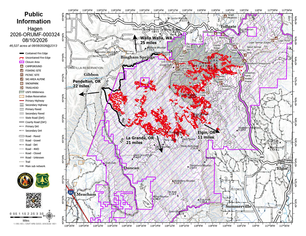
FIRE UPDATE: The Hagen Fire reached Highway 204 on Sunday, Aug. 9 near the Sprout Springs Ski Area, prompting the highway to remain closed for the foreseeable future to protect firefighter and public safety, according to the Northern Rockies Team 6 Incident Management Team.
Several fire spots spread to the east side of the highway, but firefighters contained them all. Crews will remain vigilant for additional spots as fire activity continues, fire officials said.
If conditions allow, firefighters will conduct defensive burning operations in the Sprout Springs area. Crews also will continue assessing and preparing structures in the Tollgate area on Monday, Aug. 10. Fire activity today is expected to be similar to yesterday, fire officials said.
Firefighters generally use two approaches to suppress wildfires: “go direct” and “go indirect.” A “go direct” attack involves working immediately at the fire’s edge to limit the fire’s footprint. Crews can use this approach only when terrain and conditions are favorable. Steep or rocky terrain, overhead hazards or intense fire activity can make direct suppression unsafe or impractical.
When conditions are too severe, firefighters use a “go indirect” approach, constructing or reinforcing fire lines at a safer distance from the fire front. Rivers, ridges and roads can serve as natural barriers, while crews may also remove vegetation or dig trenches to create additional lines.
Once an indirect line is completed, firefighters may conduct a strategic burn on the fire side of the line when conditions are favorable. Removing fuels near the line creates a buffer intended to slow or stop the advancing fire. Firefighters are using indirect lines and strategic burning in several areas of the Hagen and Paradise fires, with additional burning planned as conditions allow.
The Hagen Fire has burned approximately 49,638 acres and is 11% contained as firefighters work to hold the fire near Highway 204 and protect the surrounding area, fire officials said.
Firefighters worked throughout Sunday to hold the fire at the highway. Several spot fires crossed to the east side of Highway 204, but crews located and contained them Sunday night.
Fire managers are planning strategic burning along the southern end of Highway 204 to create a barrier between the advancing fire and unburned fuels. The operation will be conducted only if conditions allow.
Structure protection plans are in place for the Tollgate area, including the Langdon Lake area, but crews have not yet needed to implement those measures.
A spot fire discovered Sunday south of Bingham, on the western side of the Hagen Fire, is estimated at seven acres. The fire is in difficult terrain, requiring crews to be shuttled in by UTV for several miles. Fire leadership is confident the spot will be contained soon.
On the east side of the 31 Road, all known spot fires have been wrapped with fireline and are contained. Crews are expected to complete preparation work today along the 160 Road on the southeast side of the fire.
Fire behavior increased around 2 p.m. Sunday, with groups of trees torching and the fire making small uphill runs in some areas.
The fire is now established on the north side of the North Fork of the Umatilla River, prompting officials in Umatilla and Union counties to evaluate evacuation levels.
Residents should monitor official evacuation information and be prepared for changes as fire conditions evolve.
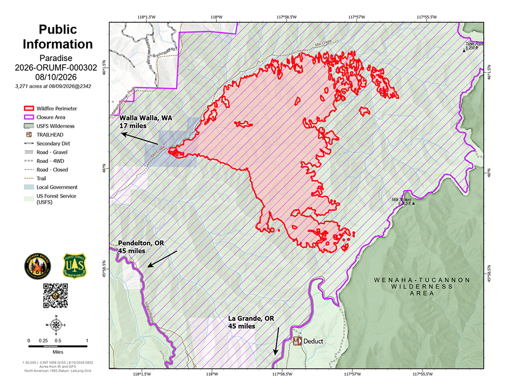
The Paradise Fire has burned approximately 3,155 acres and remains 0% contained as firefighters work to slow its spread and protect homes and infrastructure, fire officials said.
On the north side of the fire, crews continue to hold the fire south of Mill Creek. The fire has crossed Mill Creek east of the main fire in the upper drainage, but officials said the fire is not currently threatening homes or infrastructure in that area.
To the southeast, the fire is expected to reach the 64 Road Monday or Tuesday. Firefighters have been preparing the road for use as a fire line.
Sunday evening, the fire crossed Paradise Creek and began moving up Broken Ridge. Crews are scouting the ridge to determine whether an indirect handline can safely be constructed along the ridgetop.
Fire managers are planning to establish a spike camp on the north side of the fire to provide firefighters with closer access to the fire area.
Structure protection and evacuation-route preparation continue on the west side of the fire.
Umatilla and Walla Walla counties are evaluating evacuation levels daily for areas along Mill Creek and the west side of the forest boundary as fire conditions change.
Residents can find additional information about fire personnel, heavy equipment advisories and other emergency information through Walla Walla County Emergency Management’s Facebook page and website.
Residents in affected areas should continue to monitor official evacuation information and be prepared for changes as conditions evolve.